Archeology, which studies past societies, has traditionally relied on excavation methods, which involved digging up and physically destroying sites. However, with growing concerns about environmental preservation and the destruction of irreplaceable artifacts, archaeologists are increasingly turning to remote sensing technologies to explore the past with minimal impact.
Remote sensing offers a set of non-invasive techniques that allow archaeologists to peer beneath the earth's surface and discover hidden archaeological sites without the need for excavation. These methods include:
Satellite imagery: Earth-orbiting satellites capture high-resolution images that can reveal subtle variations in terrain, vegetation, and soil composition, often indicating the presence of buried archaeological structures.
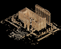
Aerial Surveying and LiDAR: Aircraft equipped with specialized cameras and LiDAR (Light Detection and Ranging) systems can collect even more detailed data, creating 3D maps of archaeological sites with extraordinary accuracy
Geophysical survey: Techniques such as magnetometry and ground-penetrating radar (GPR) measure variations in the Earth's magnetic field and electrical conductivity, respectively, to detect buried structures, artifacts, and anomalies.
Application of remote sensing in archaeology:
Remote sensing has proven invaluable in a wide range of archaeological applications, including:
Site detection and mapping: Remote sensing surveys can rapidly identify and map potential archaeological sites over vast areas, saving time and resources compared to traditional ground-based methods.
Characterization of archaeological objects: Detailed imaging and geophysical data can reveal the size, shape and internal structure of buried objects, allowing archaeologists to better understand their function and significance.
Monitoring and conservation: Remote sensing can be used to monitor archaeological sites for erosion, looting and other threats, allowing for timely intervention and conservation efforts.
Companies using remote sensing in archeology:
Numerous companies are at the forefront of the development and application of remote sensing technologies for archaeological research. Some notable examples include:
Aerial archaeology. This British company specializes in aerial remote sensing using LiDAR and photogrammetry, providing high-resolution 3D data for archaeological sites around the world.
ArchaeoTerra: With expertise in satellite image analysis and geophysical surveys, ArchaeoTerra offers comprehensive remote sensing solutions for archaeological projects of all sizes.
DigitalGlobe: A leading provider of satellite imagery, DigitalGlobe offers a large archive of data that can be used for archaeological research, including historical images for change detection studies.
The future of remote sensing in archaeology:
As remote sensing technologies continue to develop and become more accessible, their role in archeology is only expected to grow. Archaeologists will increasingly integrate remote sensing data into their research, leading to a more complete and detailed understanding of the past.
Remote sensing has revolutionized archaeology, providing archaeologists with powerful tools to explore the past with minimal environmental impact. Using these technologies, archaeologists can continue to unravel the mysteries of our shared history, preserving our precious cultural heritage for future generations.

Comments
Post a Comment